


Analyse EO data interactively with Geospatial Explorer
Geospatial Explorer Version 4 introduces on-demand algorithm execution, helping Earth Observation projects make research outputs more accessible, reusable, and operational.

The European Space Agency’s Application Propagation Environments (APEx) initiative has released Version 4 of Geospatial Explorer, expanding how Earth Observation (EO) projects share, visualise, and analyse geospatial information through interactive web-based applications.
The latest release introduces support for on-demand execution of APEx-compliant algorithm services, allowing users to run EO analysis directly within the Geospatial Explorer interface for their own areas of interest and time periods.
Earth Observation projects often generate valuable datasets, algorithms, and scientific outputs, but making those results accessible to broader audiences can remain a challenge.
Geospatial Explorer was developed to address that gap by providing a configurable environment where EO projects can publish interactive dashboards that combine maps, charts, statistics, time-series analysis, and geospatial storytelling in a single web application.
“We’re seeing a shift from simply publishing Earth Observation results to creating experiences where users can interact with data, explore trends, and run analyses for themselves. This release brings those capabilities together in a way that makes EO research more accessible and reusable.”
Building Infrastructure for Global Reusable EO Innovation
Launched in April 2024, APEx supports ESA Earth Observation projects by providing a common framework for sharing algorithms, datasets, applications, and project results.
APEx also enhances and transitions ESA’s research results into operational cloud services, providing businesses and other end-user communities with long-term access to validated EO algorithms.
The initiative combines several integrated services, including:
Together, these tools enable EO projects to publish, discover, visualise, and operationalise research and project outputs through a common cloud-native environment.
The platform is already supporting approximately 20 research projects spanning environmental monitoring, agriculture, climate applications, and future satellite mission preparation.

“Many Earth Observation researchers are experts in science, not software development. Geospatial Explorer gives project teams a way to create tailored applications without building and maintaining custom web platforms, allowing them to focus on delivering scientific value to their user communities.”
On-Demand Analysis to Support Real-World Applications
The most significant enhancement in the latest release is the ability to execute APEx-compliant algorithms directly from within Geospatial Explorer.
Version 4 also enables users to request processing services for specific locations and time periods in the browser, without needing to manage cloud infrastructure or deploy custom software themselves.
Workflows that are available on demand in the APEx Algorithm Catalogue include:
-
Agricultural parcel delineation
-
Urban heat island detection
-
Data compositing
-
Biophysical parameter generation
-
Environmental monitoring applications
Algorithms execute on the platforms where they are hosted, while APEx acts as an orchestration layer that routes requests between users and services. This architecture allows algorithm developers to expose sophisticated EO capabilities while maintaining flexibility and scalability across multiple computing environments.
At the same time, businesses and other end users can run these algorithms directly from Geospatial Explorer, saving time and set-up costs.
Customise the Geospatial Explorer with No-code Configuration
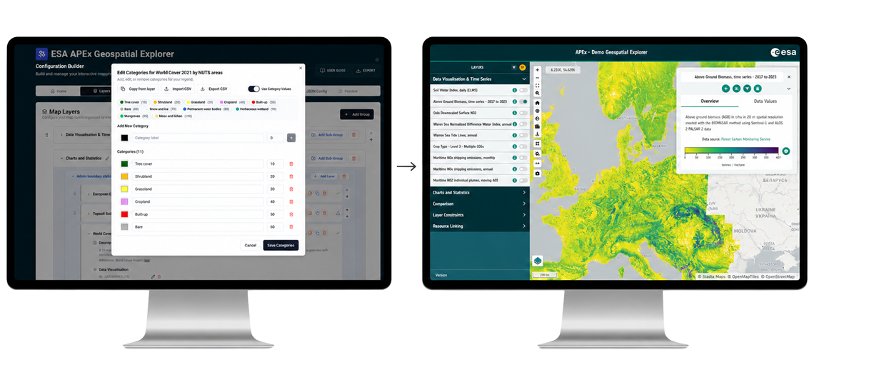
Another key component of Geospatial Explorer is the Configuration Builder, a no-code authoring environment for creating customised geospatial applications, without needing web development expertise. These geospatial applications include features such as interactive maps, charts, statistics, and time-series visualisations.
Using a browser-based interface, project teams can easily design and customise the Geospatial Explorer user interface, branding, datasets, visualisations, and functionality for their target audience. This approach helps reduce development effort while making advanced EO tools more accessible to research communities.
Explore the New Release
Geospatial Explorer Version 4 expands the operational capabilities of APEx, an ecosystem already being used across a range of operational and research activities.
As EO data proliferates in volume and sophistication, APEx makes research outputs accessible, reusable, and interoperable to different user communities. For more information, visit the APEx Demo Portal or contact the APEx team at apex@esa.int.
About APEx Geospatial Explorer
Geospatial Explorer is a configurable web-based application within ESA’s APEx initiative that enables Earth Observation projects to visualise, share, and interact with geospatial, tabular, and time-series data through interactive dashboards. The platform supports cloud-native geospatial standards and provides no-code tools for configuring EO applications tailored to specific project needs.